


Mount Coot-tha lies approximately 6 kilometers west of the Brisbane CBD, and is the highest peak in the Brisbane Urban Area. With a reserve that covers 1600 hectares of Australian bush and forest, it is a natural drawcard for local Brisbane hikers and nature lovers. Hiking is not the only attraction of Mount Coot-tha, though, with the iconic peak also home to an amazing lookout, Botanic Gardens and Planetarium. In this Guide to Mount Coot-tha, I will cover all you need to know to make the most out of this amazing Brisbane location.
This article may contain affiliate links. If you click on those links and make a purchase, at no extra cost to you I will get a small commission. This will go a long way toward keeping this website running. As always, thank you for your support! Click HERE for more information.
A bit about Mount Coot-tha
Mount Coot-tha sits 302m above sea level, and is an iconic sight on the Brisbane skyline. It is surrounded by local Brisbane suburbs of Chapel Hill, Toowong, The Gap and Bardon, and access into the Mount Coot-tha Reserve can be found from all of these locations via road or the hiking trail network.
The Mount Coot-tha Reserve is the Eastern most part of the Brisbane Forest Park, and borders the D’Aguilar Range which is home to Mount Glorious and Mount Nebo. The Reserve has been used by locals for hiking since the 1860’s, and was once only accessible from Toowong Cemetery via a walking track, which was later widened for buggy use, becoming Coronation Drive and later still Sir Samuel Griffith Drive. That name has lasted until today, and leads up the mountain, past the Mount Coot-tha Summit Lookout, around past the television stations, and completes the loop by linking back onto itself at the Brisbane Botanic Gardens.
The television towers on the summit have been located on Mount Coot-tha since the 1960’s. The Botanic Gardens and Planetarium came in the 70’s, and constant upgrades to the facilities and hiking trails around the mountain have continued ever since.
There are plenty of things to see and do at Mount Coot-tha, and a lot of interesting history surrounding the area. In this Guide to Mount Coot-tha, I am going to highlight a few of those places, and have a look at some of the things that I found interesting growing up and living at the foot of the mountain.
The Mount Coot-tha Lookout
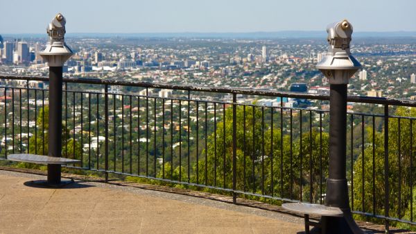
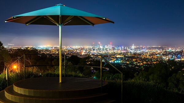
The most popular activity for most visitors to Mount Coot-tha would be the Mount Coot-tha lookout. This amazing spot is actually the highest point in the City of Brisbane, and features panoramic views that stretch from North of Brisbane, all the way around to the distant Gold Coast Hinterland. There is a wonderful viewing platform at the lookout where visitors can pose for photos, use the giant binoculars, or simply enjoy the view of the city.
There are several ways to get to the lookout, the easiest being by road. There is plenty of parking for private vehicles, but you can also get up to the lookout by catching the council bus. Many of the locals, especially on weekends, can also be seen riding their bicycles up the mountain!
The other way to get to the lookout that is becoming more and more popular is via the walking trails. Park at the bottom of the mountain and take the trail to the top. The easiest of these is the Summit Track that starts at the JC Slaughter Falls parking area. Also, you can park at Chapel Hill and take the Honeyeater Track, which reaches the summit just across the road from the Summit Track.
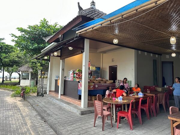
Taking in the views is not the only thing to do at the Lookout, with a wonderful Restaurant/café adjacent to the lookout itself, as well as a souvenir shop. This is very popular on the weekends, and can become very busy at all hours of the day and into the evening past sunset.
Brisbane Botanic Gardens and Planetarium
At the base of Mount Coot-tha there is the Brisbane Botanic Gardens and Planetarium. Both are amazing places to visit, and a guide to Mount Coot-tha would be remiss not to mention them!
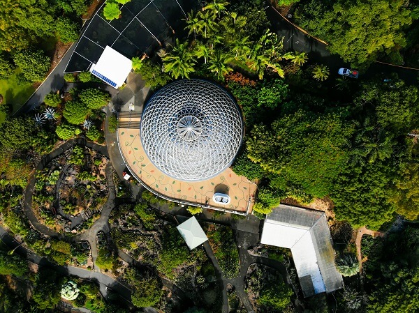
The Botanic Gardens were built in 1970, and were to replace the original Botanic Gardens in the Brisbane CBD that were prone to flooding. Those gardens remain, though, and are now known as the Brisbane City Botanic Gardens. In 1976, the Mount Coot-tha Botanic Gardens were officially opened and named the Brisbane Botanic Gardens. They cover 52 hectares, and are recognized as Queensland’s Premier Subtropical Botanic Gardens. They feature a Japanese Garden, Tropical Dome, both guided and self-guided walks, and the Brisbane Planetarium can also be found on the grounds.
Hiking at Mount Coot-tha
The activity that kept me coming back to Mount Coot-tha on a daily basis was the hiking. I am not alone, either, with hundreds of people heading to the mountain to hike every week. In fact, on weekends some of the trails can get quite crowded. Not to worry, though, as there are over a hundred established trails throughout the Mount Coot-tha Reserve, and in this Guide to Mount Coot-tha, I am going to run you through some of my favorites.
Firstly, where do you go to find the trailheads? The answer isn’t actually an easy one, as the trails around Mount Coot-tha can be accessed from anywhere. nearly every surrounding suburb has a track at the end of the street that leads off into the bush. So wherever you live, take a look at a map and start from there.
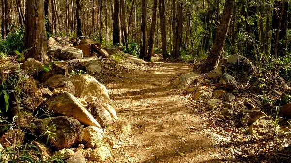
If you are coming from further afield, then I would suggest you head into the parking areas at either JC Slaughter Falls, or Simpson Falls. Both these spots will get you to numerous trailheads, and you can easily get started. One of the other places I used to enjoy starting from was Chapel Hill, where it was easy to park and hit an uphill trail right from the start. If you want to start with a flat section, or down hill and leave the uphill till the second half of your trek, then head up toward the Lookout or television stations where you will find plenty of picnic areas and trailheads.
My favorite trails were always from Simpson Falls or Chapel Hill. At the Falls parking area, you can access Simpson Falls Track, branch onto Eugenia Track, and back again. This is about a 4 km circuit and crosses the creek a couple of times. The beauty of Mount Coot-tha, though, is that you can mix and match your circuits, especially once you get to know the trails. There are plenty of sign posts though, so you won’t get lost.

At Chapel Hill I always used to hike the Honeyeater track up toward the lookout, and then come back down the Reservoir Track. If you want a longer hike and want to get the blood pumping, try hiking up Reservoir, down Chapel Hill Track and branch onto Golden Orb Track. This will take you to Lookout Trail and up to the Lookout Carpark. You can then trek along the road and follow Honeyeater back to your car. I used to do this trek a lot, and it is a leg burner!
Check out THIS LINK, for a full downloadable map to the Mount Coot-tha hiking trails and hiking Guide to Mount Coot-tha. I found the map invaluable when I was learning my way around the Reserve, and you will also find copies of it displayed in the major carparks at JC Slaughter Falls and Simpson Falls.
Hauntings at Mount Coot-tha?
Ok, so you are probably wondering what I am talking about here, but there is also a bit of a dark history to Mount Coot-tha, as there is to many old locations around Australia. I include it in my Guide to Mount Coot-tha for two reasons. One – it is part of the history of the area, and Two – well, it is part of the history of the area!
There has been suicides, accidental deaths and murders around Mount Coot-tha ever since people began to explore it. From murder at JC Slaughter Falls, to a worker falling to his death from the television tower at Channel 7. Events such as these are always surrounded by unexplained phenomena, sightings and occurrences. For example, a ghostly apparition has been sighted on the first level of the Channel Seven Tower Gantry on numerous occasions by workers late at night.
The one that I want to mention right now is around the JC Slaughter Falls area. Now, I have explored most of the trails around the mountain, many on numerous times. I switch and change every day, and sometimes follow trails at a whim, and branch off established trails to follow slightly overgrown tracks just to see where they go.
There is one such track that leads from the Ghost Hole Track/ Powerful Owl Trail across toward the JC Slaughter Falls. Of all the trails around the mountain, this became one of my favorites. It seemed to lead through a very quiet part of the Reserve, away from other walkers and nowhere near other tracks. I only ever walked it on 2 or 3 occasions, though, as I always got the creepy feeling of being followed. I mean, I felt that someone was right behind me. On one such occasion I felt like I walked right through a fog bank and the temperature dropped by about 6 degrees. Needless to say I got out of there and decided, reluctantly, not to return again.
I never, ever felt like that anywhere else on Mount Coot-tha. In fact, I always felt completely safe everywhere else on the mountain as the trails are so well maintained and frequently walked. But I stopped going to THAT one!
How to get to Mount Coot-tha
This wouldn’t be a guide to Mount Coot-tha without mentioning the easiest ways to get there!
The best and most direct way for most to get up to Mount Coot-tha is to self drive. Head to Toowong and follow the Mount Coot-tha Road and Sir Samuel Griffith Drive past the Botanic Gardens and up to the Lookout. You can then drive the entire loop, or even stop in at any of the fantastic picnic and playgrounds that can be found around the summit or Falls areas.
You can ride your pushbike, as many do, especially on weekends, and follow the cycleways all the way to Mount Coot-tha.
The easiest way for tourists in Brisbane, though, is simply to catch the bus from the CBD. Bus number 471 takes you all the way to the Summit Lookout, so you can’t go wrong. Pick it up in Adelaide Street, around Cathedral Adelaide Street Stop 34 if you want to be exact!
Check out THIS LINK for Brisbane City Buses and TransLink timetables.

Summary
Well that is it for my Guide to Mount Coot-tha. It is an historic and amazing place to visit. If you are interested in seeing Brisbane from a panoramic viewpoint, then you cannot go wrong by taking a trip to the lookout. If you simply want to get some exercise, and are interested in hiking or walking through natural settings, the hikes and trails around Mount Coot-tha are simply perfect for that. In fact, many trail runners love the Summit Track in particular due to the sure footing and well trodden path.
So get out and check out Mount Coot-tha next time you are in Brisbane!
Now, I will sign off on this Guide to Mount Coot-tha with a few handy links.
Handy Links
Brisbane City Council – Mount Coot-tha Reserve
Mount Coot-tha Hiking Trail Map
Translink – For bus timetables
Complete Guide to South East Queensland
DON’T FORGET to leave a comment below. I promise to reply!